Storm Bram Bears Down on UK - 90 mph Gusts, Torrential Rain and Widespread Travel Chaos Expected
The UK braces for severe disruption as Storm Bram sweeps in with 90 mph winds, heavy rain, and “danger to life” warnings. Coastal communities, travellers and commuters face flood risk, travel delays, and power outages - essential precautions ahead of the storm.
As Met Office and UK meteorologists warn of “danger-to-life” conditions, the newly-named Storm Bram is poised to batter large swathes of the United Kingdom with wind gusts up to 90 mph, heavy rainfall, and major travel disruption. The impact could be severe - especially in coastal and exposed areas, where strong gusts, flooding, and disrupted transport are all likely. (Sky News)
Warnings Issued: Who’s Under Threat?
The Met Office has issued a series of warnings as Storm Bram approaches:
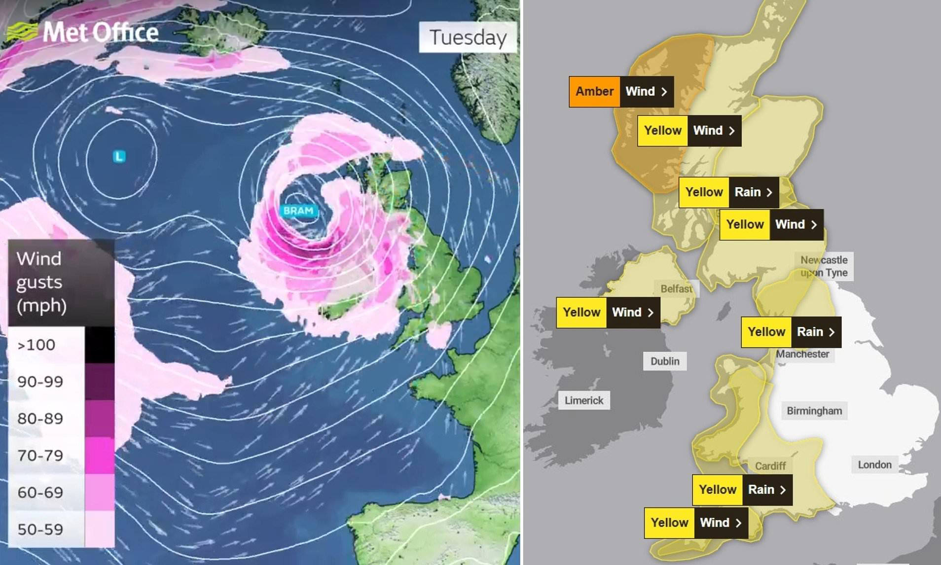
• An amber “danger to life” wind warning is in force for north-west Scotland (Highlands and Eilean Siar), where gusts could hit 90 mph between Tuesday evening and midnight. (Met Office)
• Amber rain warnings cover parts of south Wales, southwest England, and south Devon, with up to 100 mm of rainfall possible - enough to trigger flooding on already saturated ground.
• Widespread yellow warnings for wind and rain are in place across much of Scotland, Northern Ireland, northern and southwest England, and Wales - meaning even areas outside the amber zones should brace for disruption. (The Independent)
According to Met Office forecasts, while the worst impacts are expected along coasts and high ground, gusts of 50–70 mph are likely to cause disruption more widely across the UK. (Met Office)
What to Expect - From Rainfall to Power Cuts
As the storm strikes, residents and travellers are advised to stay alert. Forecasters warn that:
• Heavy and persistent rain could drop 50–75 mm over several hours, with isolated spots potentially recording 100 mm - an amount comparable to half a typical month’s rainfall in just one day.
• Flooding is likely, especially in low-lying or poorly drained zones. Fast-flowing water could cut off roads, inundate homes or businesses, and create dangerous conditions. (Yahoo News)
• High winds and wind-blown debris pose a risk to life - falling trees, flying roof tiles and structural damage are all concerns.
• Major disruptions to transport networks - roads, bridges, trains, ferries and flights are all vulnerable to closures, cancellations or delays.
• Power outages and damage to buildings are possible, especially in coastal or exposed areas.
As one meteorologist put it: “It only takes one tree falling in the wrong place at the wrong time to have a significant impact.” (Sky News)
Where the Storm Will Hit Hardest
While Storm Bram’s effects will be felt widely, some regions are at greater risk:
• Northwest Scotland (Highlands, Eilean Siar, Argyll & Bute) - under amber wind warning, expecting up to 90 mph gusts and dangerous coastal conditions.
• South Wales and Southwest England (including Devon, Cornwall) - heavy rain could lead to flooding; coastal areas may see dangerous waves and spray.
• Wales’ inland and high-ground zones (including south Wales valleys and Dartmoor) - with rainfall and wind combined, risk of flooding and transport disruption is significant. (The Independent)
• Coastal and exposed areas across the west coast of Britain - vulnerable to wind, spray and rising sea levels under Storm Bram’s onshore push.
Voices from Forecasters - Real Dangers, Real Advice
The scale and severity of Storm Bram prompted unusually urgent language from meteorologists and weather agencies. The amber warnings issued by the Met Office carry the label “danger to life”, a sobering classification reserved for the most hazardous weather.
Met Office Chief Forecaster Dan Suri warned that the combination of strong wind, heavy rain and saturated ground could result in “flooding impacts.” He urged people to secure loose items, prepare for possible power interruptions, and avoid unnecessary travel.
Meanwhile, transport authorities across rail, ferry and road networks have already begun issuing advisories to travellers: check ahead before travelling, expect delays or cancellations, and avoid coastal routes if possible. (Facebook)
What You Should Do Right Now
If you live in, or are travelling through, an affected region, consider the following precautions:
• Secure outdoor furniture, garden items, and anything that could be blown by wind.
• Avoid unnecessary travel - especially along exposed coastal roads, high ground, or flood-prone areas.
• If you must travel, allow extra time, check the status of ferries, trains and flights, and avoid driving through flood water.
• Prepare for possible power cuts: keep torches, spare batteries, and essential supplies ready.
• Stay updated via official weather alerts, news media, and local authorities.
What Happens Next - and Why Bram Matters
Storm Bram is the latest in a growing trend of intense, fast-moving storms striking the UK - part of the 2025–26 European windstorm season. The naming, by the Met Office and partner agencies such as Met Éireann in Ireland, helps ensure clear communication about high-impact weather threats.
The storm is expected to sweep northeastwards through Tuesday, gradually weakening by Wednesday - though isolated showers and gusts may linger.
But the effects of Bram could last longer than the rain and wind. Flooding, structural damage, power outages and travel disruption may continue into midweek. Residents, businesses and emergency services are being urged to remain alert and prepared.
Final Word
Storm Bram is not just another rainy day: the combination of fierce winds, coastal surges, heavy rain and saturated ground makes it a serious threat. As authorities issue amber “danger to life” warnings, now is the time for preparation, caution and vigilance.
If you are in a high-risk area - especially coastal regions, exposed coasts, or flood-prone zones - take the warnings seriously, follow official advice, and stay safe. Bram may pass quickly, but its aftermath could linger for days.