Hurricane Polo: How the Powerful Pacific Storm Is Threatening Mexico with Devastating Floods and Landslides
Hurricane Polo has intensified into a Category 5 storm off Mexico’s Pacific coast, bringing threats of devastating flooding, mudslides, dangerous surf and coastal disruption.
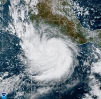
Hurricane Polo has rapidly intensified into one of the most powerful storms of the 2026 Pacific hurricane season, placing Mexico’s southwestern Pacific coast on high alert as forecasters warn of life-threatening flooding, mudslides, dangerous surf and strong winds.
As of September 23, Polo remained offshore rather than making a direct landfall. However, its extraordinary strength and proximity to Mexico have already produced dangerous coastal conditions, while heavy rainfall associated with the hurricane threatens communities in several states.
The U.S. National Hurricane Centre (NHC) classified Polo as an extremely dangerous Category 5 hurricane, with maximum sustained winds reaching about 165 mph (270 km/h) in its September 22 advisory. By early Wednesday, the storm remained essentially stationary south of Mexico, with a central pressure of about 905 millibars.
Polo's Rapid Intensification
One of the most remarkable features of Hurricane Polo has been how quickly it strengthened.
According to reports, Polo developed from a tropical storm into a Category 5 hurricane in less than two days. Its rapid intensification has been linked by meteorologists to exceptionally warm ocean waters and favourable atmospheric conditions over the eastern Pacific.
The storm became the third Category 5 hurricane of the 2026 Pacific season, following Hurricanes Genevieve and Lowell.
Its maximum sustained winds briefly reached around 180 mph according to National Hurricane Centre observations reported by the Associated Press, placing Polo among the most powerful Pacific hurricanes recorded in recent years.
The speed at which Polo strengthened has increased concerns for communities along Mexico's Pacific coast, because rapidly intensifying hurricanes can reduce the amount of time available for residents and authorities to prepare.
Mexico's Pacific Coast Faces Major Threat
Although Polo was forecast to remain offshore, the storm's effects were expected to extend well beyond its centre.
The states of Guerrero and Michoacán face the greatest rainfall threat, with the National Hurricane Centre forecasting several inches of rain and isolated higher totals. Such rainfall can rapidly overwhelm drainage systems, rivers and streams, particularly in mountainous areas.
The NHC warned that rainfall from Polo could produce life-threatening flooding and mudslides, especially in steep terrain. Coastal portions of Oaxaca, Colima and Jalisco were also expected to receive significant rainfall.
Mexico's authorities consequently issued tropical-storm warnings along portions of the coast, while emergency agencies and the National Guard prepared for possible flooding and other storm-related emergencies.
Flooding and Mudslides Could Cause the Greatest Damage
For many communities, rainfall rather than the hurricane's strongest winds could prove to be the most immediate danger.
Southwestern Mexico has mountainous terrain, meaning intense rainfall can quickly trigger landslides and mudflows. Roads can become impassable, bridges can be damaged, and isolated communities can be temporarily cut off.
The National Hurricane Centre said Polo could produce between 3 and 6 inches of rain, with isolated maximum totals of up to 8 inches in coastal parts of Guerrero and Michoacán through Thursday. Additional rainfall of 2 to 4 inches was possible in coastal portions of Oaxaca, Colima and Jalisco.
Earlier forecasts had suggested rainfall totals could reach as high as 12 inches in isolated locations.
The threat is particularly serious where saturated soil combines with steep slopes, increasing the potential for sudden landslides.
Dangerous Surf and Rip Currents
Polo is also generating powerful ocean swells along Mexico's Pacific coastline.
The National Hurricane Centre warned that these swells could create life-threatening surf and rip-current conditions. Even areas outside the strongest winds can therefore experience dangerous sea conditions.
The combination of large waves, strong currents, high tides and storm-driven coastal flooding can pose risks to swimmers, fishermen, boat operators and coastal communities.
Authorities have urged residents and visitors to follow local warnings and avoid entering dangerous waters while the storm remains active.
Why Polo Became So Powerful
Meteorologists have pointed to unusually warm Pacific waters and a strong El Niño pattern as important factors behind the storm's rapid strengthening.
The Guardian reported that 2026's El Niño has contributed to particularly active conditions in the Pacific while suppressing hurricane development in the Atlantic. Polo's explosive intensification occurred in an environment featuring unusually warm ocean temperatures and favourable atmospheric conditions.
However, the precise contribution of climate change to any individual hurricane requires scientific analysis beyond simply observing warm ocean temperatures. What is clear is that warm water provides hurricanes with additional energy, while atmospheric conditions determine whether that energy can be efficiently converted into stronger winds.
Potential Effects Beyond Mexico
The influence of Hurricane Polo may extend beyond the immediate Mexican coastline.
Meteorologists have warned that moisture associated with the storm could contribute to heavy rainfall farther north, including parts of the southwestern United States. Southern California has also been monitoring the storm because of possible changes in moisture, surf and coastal conditions.
However, the impacts away from Mexico are expected to be considerably less severe than those facing areas closest to Polo.
A Powerful Storm That Has So Far Stayed Offshore
One important distinction remains: despite Polo's extraordinary strength, it had not made a direct landfall in Mexico as of September 23.
That means reports describing devastating destruction should be treated carefully. The major danger at this stage comes from the storm's rainfall, coastal conditions, flooding potential and mudslides rather than confirmed widespread destruction from a direct Category 5 landfall.
The storm's slow movement offshore, however, means communities cannot yet assume that the danger has passed.
The National Hurricane Centre continues to warn of hazardous conditions along the southwestern Mexican coast, while authorities maintain tropical-storm warnings in affected areas.
What Happens Next?
The next stage of Hurricane Polo's development will depend heavily on its movement, interaction with surrounding atmospheric conditions and distance from Mexico's coastline.
For residents of Guerrero, Michoacán, Oaxaca, Colima and Jalisco, the immediate priority remains preparation for heavy rainfall, flooding, landslides, dangerous surf and possible disruption to transport and other services.
Polo has shown how quickly a tropical system can become a major threat. Its rapid intensification from a relatively weak storm to a Category 5 hurricane in a short period has made it one of the defining weather events of the 2026 Pacific hurricane season.
Although the storm remains offshore, its enormous size and strength mean Mexico's Pacific coast still faces a serious weather emergency as authorities monitor its next move.